Leiðarvísir is a route planner for the Reykjavík capital area that compares the ways people actually get around: walking, Strætó, Hopp scooters, bikes and the mixed trips in between, like scooter-to-bus or bus-to-scooter.
Enter a start and a destination and you get a ranked set of itineraries with real travel times, live vehicle positions and a price estimate for each one, drawn leg by leg on the map.
What it does
- Compares whole families of routes walk, bus, Hopp, and combined hopp→bus, bus→hopp and hopp→bus→hopp itineraries, pruned down to the options that are genuinely worth considering.
- Real GTFS scheduling, not headway guesses. Departures come from the actual Strætó timetable, including service calendars and exceptions, with direct and one-transfer trips scanned against the next real departure.
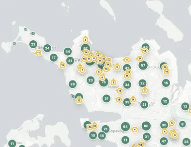
- Live data on the map. Bus positions stream from GTFS-Realtime and are interpolated between updates; Hopp vehicles show current location and battery, clustered at low zoom.
- Icelandic address and place search over Stadfangaskrá plus a curated landmark index, with fuzzy matching for typos.
- Bilingual Icelandic by default, English on a toggle.
How it's built
Next.js 16 and React 19, with Leaflet on CARTO tiles. Everything expensive or key-bearing the GTFS model, the realtime feeds, the 20 MB address index stays behind API routes so it never reaches the browser. Street geometry comes from OSRM and is fetched only for the route you actually select, which keeps the first results fast.
The GTFS zip reader, the CSV parser and the GTFS-Realtime protobuf decoder are all written from scratch, no GTFS, protobuf or CSV dependencies. Hopp vehicles render to a custom canvas layer instead of DOM markers, and rendering is suspended during pan and zoom, so the map stays smooth on phones.
Open data: Strætó GTFS, Hopp GBFS, Stadfangaskrá, OpenStreetMap.